


K2 Mountain
K2 Mountain is the second highest mountain peak in the world and the highest peak in Pakistan. It is located on the Gilgit-Baltistan region of Pakistan and Taxkorgan Tajik Autonomous Country of Xinjiang, China. Elevation of K2 mountain is 8,611 meters (28,251 ft.).
The mountain was named “Savage Mountain” due to extreme difficulty of ascent and second highest fatality rate among “Eight Thousanders”. For every four people who reached the summit, one has died trying. In early days K2 witnessed many ascents and today the peak has been climbed from all sides.
K2 Mountain was long considered unclimbable. Attempts in 1902, 1909, 1934, 1938, 1939 and 1953 all failed. The first successful ascent in 1954 started with over 500 porters, 11 climbers, and six scientists. One of the climbers died of pneumonia after 40 days of raging storms. The final ascent was made by a team of two after their oxygen supply had run out, and an emergency descent was made in darkness.
K2 Mountain is the only major mountain in the world which has surveyor’s notation as its common name (K stands for Karakoram, 2 means it was the second peak listed). T.G. Montgomery was the surveyor who assigned the peak this designation in 1856.

Climbing K2
First successful climber(s):
An Italian expedition finally succeeded in ascending to the summit of K2 via the Abruzzi Spur on 31 July 1954. The expedition was led by Ardito Desio, and the two climbers who reached the summit were Lino Lacedelli and Achille Compagnoni. The team included a Pakistani member, Colonel Muhammad Ata-ullah, who had been a part of the 1953 American expedition. Also on the expedition were Walter Bonatti and Pakistani Hunza porter Amir Mehdi, who both proved vital to the expedition’s success in that they carried oxygen tanks to 8,100 metres (26,600 ft) for Lacedelli and Compagnoni.
The ascent is controversial because Lacedelli and Compagnoni established their camp at a higher elevation than originally agreed with Medhi and Bonatti. It being too dark to ascend or descend, Medhi and Bonatti were forced to overnight without shelter above 8,000 meters leaving the oxygen tanks behind as requested when they descended. Bonatti and Mehdi survived, but Mehdi was hospitalized for months and had to have his toes amputated because of frostbite. Efforts in the 1950s to suppress these facts to protect Lacedelli and Compagnoni’s reputations as Italian national heroes were later brought to light. It was also revealed that the moving of the camp was deliberate, a move apparently made because Compagnoni feared being outshone by the younger Bonatti. Bonatti was given the blame for Medhi’s hospitalization


K2 60 Years Later 2014 a Mountaineering, Scientific, Environmental Expedition
A climbing expedition promoted by the Government of Gilgit Baltistan has been carried out with the collaboration of the EV-K2-CNR Association that is operating in the Karakorum and in the Himalayas coordinating several activities, among which a network of GNSS
permanent stations with the aim of detecting the tectonic movements of the mountain chain and of its glaciers.
The mission to Pakistan had the main purpose of providing the necessary technical assistance to the Pakistani climbing expedition denominated “K2 Sixty Years Later”, which is a reference to the Italian expedition that first climbed K2 mountain in 1954.
The expedition also included a scientific program which involved the measurement of the mountain with satellite GNSS technology. Researchers from KIU (Karakorum International Uni-versity- Gilgit), AJKU (Azad Jammu and Kashmir University- Muzaffarabad) and Poonch Univer-sity (Rawalkot) took part in this program. The computer expert of the CKNP head quarters Fida Hussain took part in the installation of the receiver in Skardu and the transmission of the data for the processing.
This had never been done in the past, because in 1996 the measurement was performed with the classical trigonometric method and in 2004 it hadn’t been possible to carry the GPS receiver to the summit due to the fall of one of the climbers.
GPS Measurement
The GPS receiver chosen for this challenging measurement has been the Leica Viva GS14, desi-gned for the most demanding environment. This GNSS receiver exceeds the toughest environ-mental specifications, going beyond industrial standards ensuring flawless performance even in the most challenging work places.
The instrument chosen for this delicate performance was the latest offspring of the Leica-Ge-osystems family, the famous company which produces high accuracy topographic instruments. This instrument, the Leica VIVA GS14, was lent to the expedition by Leica for the testing of its performances as regards portability, resistance to very low temperatures and to rugged use on rough tracks.
The instrument, presented to the researchers the day before their departure from Italy, is com-posed by an antenna which also contains the electronics and the data memorizing system, and by a controller linked via Wi-Fi to the antenna. The controller works like a computer that provi-des the right parameters to be used for the measurement.
The scientific expedition was carried out between June 22nd and the beginning of August 2014 and involved two Pakistani researchers Aamir Asghar and Hameed Fahad and two Italian rese-archers, Marcello Alborghetti and Giorgio Poretti, as well as the participation of Maurizio Gallo.
The expedition and the research were carried out with the patronage of the Italian Presidency of the Council of Ministers, the Ministry of Foreign Affairs and the Ministry of the Environment

| Elevation (meters): | 8,612 |
| Elevation (feet): | 28,253 |
| Continent: | Asia |
| Country: | Pakistan |
| Range/Region: | Karakoram Baltistan Gilgit-Baltistan Pakistan |
| Latitude: | 35.8825 |
| Longitude: | 76.5133 |
| Difficulty: | Major Mountain Expedition |
| Best months for climbing: | Jun, Jul, Aug |
| Year first climbed: | 1954 |
| First successful climber(s): | Achille Compagnoni, Lino Lacedelli (Italian expedition) |
K2 Mountain with a Drone! By Petr Jan Juračka
Discover Different Regions
 https://www.tourismpakistan.net/wp-content/uploads/2016/12/Kalash-Valley-Beauty-Chitral-Dir-Pakistan.jpg
512
512
admintpd
https://www.tourismpakistan.net/wp-content/uploads/2018/11/colored-logo.png
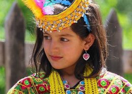
admintpd2016-12-05 13:52:372016-12-23 15:16:25Kalash Valley Pakistan
https://www.tourismpakistan.net/wp-content/uploads/2016/12/Kalash-Valley-Beauty-Chitral-Dir-Pakistan.jpg
512
512
admintpd
https://www.tourismpakistan.net/wp-content/uploads/2018/11/colored-logo.png
admintpd2016-12-05 13:52:372016-12-23 15:16:25Kalash Valley Pakistan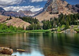 https://www.tourismpakistan.net/wp-content/uploads/2016/12/Pakistan-Natural-Beauty.jpg
420
823
admintpd
https://www.tourismpakistan.net/wp-content/uploads/2018/11/colored-logo.png
admintpd2016-12-05 13:40:462017-03-06 18:44:37Gilgit Baltistan - Pakistan
https://www.tourismpakistan.net/wp-content/uploads/2016/12/Pakistan-Natural-Beauty.jpg
420
823
admintpd
https://www.tourismpakistan.net/wp-content/uploads/2018/11/colored-logo.png
admintpd2016-12-05 13:40:462017-03-06 18:44:37Gilgit Baltistan - Pakistan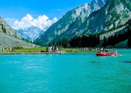 https://www.tourismpakistan.net/wp-content/uploads/2016/12/swat-beautiful.jpg
420
823
admintpd
https://www.tourismpakistan.net/wp-content/uploads/2018/11/colored-logo.png
admintpd2016-12-05 13:12:172017-05-21 09:53:37Swat Valley - Pakistan
https://www.tourismpakistan.net/wp-content/uploads/2016/12/swat-beautiful.jpg
420
823
admintpd
https://www.tourismpakistan.net/wp-content/uploads/2018/11/colored-logo.png
admintpd2016-12-05 13:12:172017-05-21 09:53:37Swat Valley - Pakistan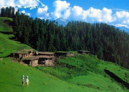 https://www.tourismpakistan.net/wp-content/uploads/2016/12/Kumrat-valley-culture.jpg
420
800
admintpd
https://www.tourismpakistan.net/wp-content/uploads/2018/11/colored-logo.png
admintpd2016-12-05 12:47:042016-12-19 19:59:12Kumrat Valley - Dir Pakistan
https://www.tourismpakistan.net/wp-content/uploads/2016/12/Kumrat-valley-culture.jpg
420
800
admintpd
https://www.tourismpakistan.net/wp-content/uploads/2018/11/colored-logo.png
admintpd2016-12-05 12:47:042016-12-19 19:59:12Kumrat Valley - Dir Pakistan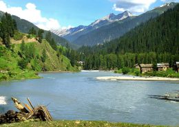 https://www.tourismpakistan.net/wp-content/uploads/2015/05/featured-image.jpg
600
800
admintpd
https://www.tourismpakistan.net/wp-content/uploads/2018/11/colored-logo.png
admintpd2016-12-04 19:42:382017-03-05 11:32:40Azad Kashmir - Pakistan
https://www.tourismpakistan.net/wp-content/uploads/2015/05/featured-image.jpg
600
800
admintpd
https://www.tourismpakistan.net/wp-content/uploads/2018/11/colored-logo.png
admintpd2016-12-04 19:42:382017-03-05 11:32:40Azad Kashmir - Pakistan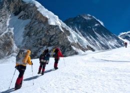 https://www.tourismpakistan.net/wp-content/uploads/2016/12/k2-mountain.jpg
675
1200
admintpd
https://www.tourismpakistan.net/wp-content/uploads/2018/11/colored-logo.png
admintpd2016-11-10 16:08:442017-05-21 13:08:06K2 Mountain-Pakistan
https://www.tourismpakistan.net/wp-content/uploads/2016/12/k2-mountain.jpg
675
1200
admintpd
https://www.tourismpakistan.net/wp-content/uploads/2018/11/colored-logo.png
admintpd2016-11-10 16:08:442017-05-21 13:08:06K2 Mountain-Pakistan

